



















Super Typhoon Champi’s giant eye highlights power of Pacific cyclones
Champi reached peak winds of 185 mph before weakening, while forecasts tracked its movement towards Taiwan and Japan’s southwestern islands.
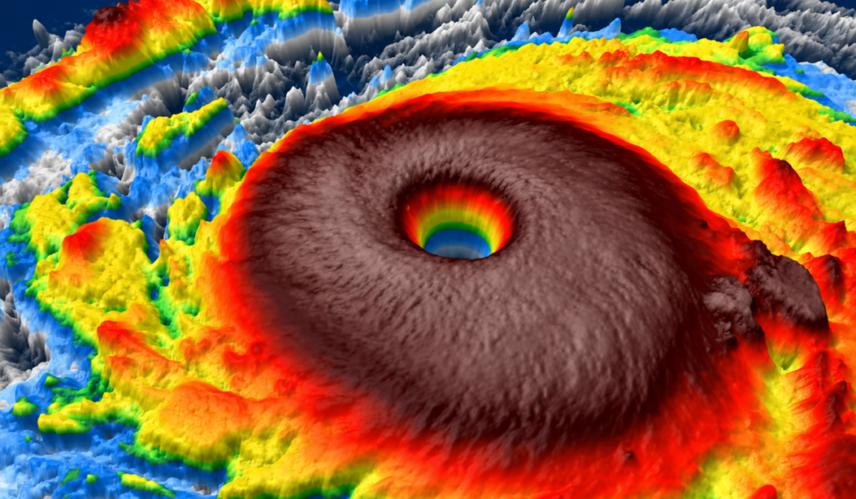
Super Typhoon Champi developed an exceptionally large eye as it intensified over the western Pacific, with satellite imagery revealing a structure reportedly wider than the US state of Rhode Island. The storm reached Category 5-equivalent intensity, recording peak sustained winds of 185 mph and gusts of approximately 215 mph, according to The Washington Post on 21 October.
The newspaper attributed the storm’s exceptional strength to favourable environmental conditions, including sea-surface temperatures of around 86–88°F and limited upper-level wind shear. These conditions can support rapid intensification by supplying heat and moisture while helping a cyclone maintain its organised structure.
Champi passed close to Guam on 18 October, moving approximately 20 miles south of the island, according to the newspaper. Although the storm’s eye avoided a direct passage over Guam, the wider storm system caused disruption across the Mariana Islands. The Associated Press reported that authorities sought emergency disaster declarations and that airports, harbours and some healthcare facilities were closed.
Champi subsequently intensified again, reaching peak sustained winds of 185 mph on 20 October, according to historical storm-tracking data. By 21 October, however, its intensity had begun to decline. The US National Weather Service’s Guam advisory, issued on 21 October, recorded maximum sustained winds of 180 mph as the storm moved west-northwest towards Taiwan.
The advisory also reported that typhoon-force winds extended up to 100 miles from the centre, while tropical-storm-force winds extended up to 290 miles. These measurements illustrate why the effects of a major cyclone can extend far beyond its eye.
Forecasts available on 21 October indicated that Champi would continue towards the seas east of Taiwan before potentially turning towards Japan’s Ryukyu Islands. The Hong Kong Observatory’s forecast placed the storm near Taiwan on 22–23 October, with further weakening projected as it moved towards Japan.
These projections represent forecasts available at the time, rather than confirmation of subsequent landfall or impacts. The storm’s actual track, intensity and effects must be assessed using updated meteorological advisories.
The central claim that Champi reached exceptional intensity is supported by contemporary reporting and official meteorological advisories. The US National Weather Service documented winds of 180 mph on 21 October, while storm-tracking records listed a peak of 185 mph on 20 October.
However, wind estimates can differ between meteorological agencies because they use different averaging periods, observation methods and forecast models. The term “Category 5-equivalent” is therefore more appropriate than treating the US Atlantic hurricane scale as the formal classification system used by every western Pacific agency.
The reported comparison between Champi’s eye and Rhode Island also requires context. An unusually large eye is a striking satellite feature, but eye diameter alone cannot establish the cyclone’s overall size, destructive potential or likely damage. Wind-field extent, rainfall, coastal exposure and storm surge are more directly relevant to assessing local hazards.
The evidence also supports caution over forecasts of impacts in Taiwan and Japan. A projected track towards an island chain does not necessarily mean that the cyclone’s centre will cross a particular island. Forecasts should be distinguished from observed events, and earlier projections should not be presented as current conditions without updated official data.
Champi demonstrates how warm ocean waters and favourable atmospheric conditions can help a tropical cyclone intensify to extreme levels. Warm seawater provides energy through evaporation and heat transfer, while low vertical wind shear can reduce disruption to the storm’s vertical structure. Neither factor guarantees a particular intensity or track, but together they can create an environment conducive to strengthening.
Its evolution also highlights the importance of monitoring changes in intensity rather than relying on a single peak-wind measurement. A cyclone can weaken after reaching its maximum strength and still retain a broad field of damaging winds. Communities can therefore face substantial risks even when the storm is no longer at its peak intensity.
For Taiwan and Japan’s southwestern islands, the key questions are the storm’s distance from populated areas, the distribution of its strongest winds and the amount of rain it produces. Coastal communities must also consider the possibility of dangerous seas and storm surge where local geography and forecast conditions make these hazards relevant.
The Guam episode offers another lesson. A cyclone can avoid a direct hit on an island while still disrupting transport, health services and other essential infrastructure. Preparedness planning must account for the full wind field and associated hazards, rather than focusing exclusively on the storm’s centre.
More broadly, Champi illustrates why reliable forecasting depends on continuous observation and clear communication of uncertainty. Satellite imagery helps meteorologists assess a storm’s structure, while official advisories provide updated information about its position, intensity and expected movement. For readers and policymakers, distinguishing observed conditions from forecast scenarios is essential to understanding the actual level of risk.
The most important measure of Champi’s significance is therefore not the dramatic appearance of its eye alone. It is the combination of extreme intensity, a wide-reaching wind field and the potential exposure of communities across the western Pacific. Timely warnings and locally relevant preparedness measures remain central to reducing the risks posed by such storms.
Sources:
- The Washington Post — See Super Typhoon Champi’s giant eye as it swirls across the Pacific, 21 October 2026
- US National Weather Service — Super Typhoon Champi, Advisory No. 27, 21 October 2026
- Associated Press — Typhoon Champi strengthens to Category 5 but moves away from land; Trudy weakens
- Hong Kong Observatory — Tropical cyclone positions and forecast, 21 October 2026
- Weather Underground — Super Typhoon Champi tracker and historical intensity data
